Geographic Information Systems (GIS) play a vital role in the modern management of environmental resources. From monitoring natural habitats to planning urban landscapes, GIS allows us to visualize and analyze data to make more informed decisions. This guide will dive into key application of GIS in environmental management, helping organizations and governments tackle critical challenges effectively.
The application of GIS in environmental management involves mapping and analyzing spatial data to monitor natural resources, track pollution, plan land use, conserve biodiversity, and manage disasters. GIS helps decision-makers visualize environmental changes and implement sustainable solutions, making it a vital tool for addressing environmental challenges effectively.
Key Applications of GIS in Environmental Management
GIS enables environmental managers to visualize, analyze, and interpret data related to the Earth’s surface. This technology plays a crucial role in addressing complex environmental challenges, from resource management to disaster response. Some of the application are:
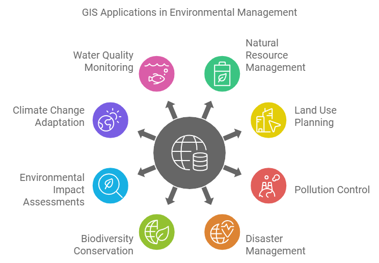
1. Natural Resource Management
Natural resources like forests, water, and minerals are finite, and their management is crucial for sustainability. GIS helps in mapping and monitoring these resources by providing accurate data on their location, quantity, and usage patterns.
By leveraging GIS, organizations can ensure sustainable resource use, avoid over-exploitation, and maintain ecological balance. Read more about the importance of geography in managing natural resources efficiently.
2. Land Use Planning and Conservation
Land use planning is essential for urban development, agriculture, and wildlife conservation. GIS provides a clear visual of land use patterns, making it easier to plan for the future.
By analyzing geographical data, authorities can ensure that urban expansion doesn’t encroach on protected areas or agricultural zones. GIS also supports land conservation efforts by highlighting areas with high ecological value that need protection.
For instance, GIS helps conservationists identify habitats critical for endangered species and develop strategies for preserving these areas. Land use models generated from GIS data offer insights into how land changes over time, guiding sustainable development.
3. Pollution Control and Monitoring
GIS is highly effective in pollution control by allowing authorities to monitor pollutant levels in the air, water, and soil. By mapping pollution sources and tracking their spread, GIS helps identify hotspots and prioritize clean-up efforts.
With GIS, authorities can implement better waste management strategies, track pollution over time, and identify critical areas where intervention is necessary. This technology also assists in monitoring changes in water quality, ensuring that pollution is kept in check.
4. Disaster Management and Preparedness
In disaster-prone areas, preparedness is key to minimizing damage. GIS helps authorities plan and execute disaster management strategies more effectively by identifying high-risk zones, mapping evacuation routes, and monitoring natural disasters in real-time. Whether it’s floods, wildfires, or earthquakes, GIS offers an in-depth analysis of areas vulnerable to environmental disasters.
By simulating disaster scenarios, GIS can also help in formulating response plans and assessing potential damage. For instance, flood-prone regions can be mapped out, enabling the implementation of early warning systems that save lives. Discover how GIS contributes to remote sensing applications, which enhance disaster preparedness.
5. Biodiversity Conservation
GIS plays a critical role in biodiversity conservation by mapping species distributions and monitoring habitat conditions. Conservationists use GIS to identify biodiversity hotspots and track changes in ecosystems due to human activities or natural processes. With spatial data, they can prioritize conservation efforts and allocate resources efficiently.
GIS also aids in tracking migratory patterns of animals and monitoring the impact of climate change on species’ habitats. This technology helps preserve endangered species and maintain ecosystem balance by visualizing how different factors affect biodiversity over time.
6. Environmental Impact Assessments
Before any major construction or industrial project begins, an environmental impact assessment (EIA) is necessary. GIS facilitates EIAs by providing a detailed analysis of the geographical area and potential environmental changes. It allows developers and policymakers to visualize the long-term effects of their projects on ecosystems, helping them mitigate negative impacts.
For instance, GIS can predict how infrastructure development might affect local water systems or wildlife habitats. With this data, planners can make more eco-friendly decisions, ensuring sustainable development. Explore why maps are useful to geographers in environmental assessments.
7. Climate Change Adaptation
GIS is an essential tool in combating climate change. It allows scientists to model climate patterns, analyze how regions are affected by global warming, and plan adaptation strategies. For instance, GIS can map areas most vulnerable to rising sea levels, enabling authorities to take preventive measures.
Additionally, GIS helps in monitoring deforestation and other environmental changes that contribute to climate change. It enables policymakers to develop effective strategies for reducing emissions and adapting to changing environmental conditions.
8. Water Quality Monitoring
Water quality is essential for both human consumption and ecosystem health. GIS enables continuous monitoring of water sources, allowing for the detection of contaminants and pollution sources. By mapping water bodies and their surrounding areas, GIS helps identify regions at risk of pollution and assists in ensuring the availability of clean water.
Industries and government bodies rely on GIS for water quality assessments, helping them implement better waste management and pollutant control strategies.
9. Urban Planning and Development
Urban planners use GIS to design cities that are sustainable and efficient. By analyzing land use patterns, infrastructure, and population data, GIS enables planners to make informed decisions about where to allocate resources. GIS helps balance urban development with environmental conservation, ensuring that growth doesn’t compromise ecosystems.
For instance, GIS allows for the identification of green spaces within urban areas, contributing to a healthier environment and improved quality of life. Learn more about how geography affects civilization and urban development.
10. Wildlife Habitat Analysis
Wildlife habitats are often under threat from human activities, and GIS provides conservationists with the tools to analyze these habitats effectively. By mapping animal populations and monitoring habitat changes, GIS supports wildlife conservation efforts.
GIS allows authorities to track the movement of species, identify critical habitats, and implement protection measures for endangered species. It plays a pivotal role in preventing habitat loss and preserving biodiversity.
11. Soil Mapping and Management
Soil is a vital resource for agriculture and ecosystems, and GIS helps in mapping and managing soil quality. By analyzing soil types and their distribution, GIS supports sustainable agriculture practices and land management strategies.
Soil mapping with GIS can help farmers identify areas that need soil conservation measures, thereby increasing productivity and ensuring long-term soil health. This technology is crucial for maintaining food security and preventing soil degradation.
12. Public Health Monitoring
Environmental factors greatly impact public health, and GIS helps track these factors to predict and prevent health issues. By mapping areas affected by pollution, disease outbreaks, or poor sanitation, GIS allows health authorities to take preventive measures and allocate resources more effectively.
For example, GIS has been instrumental in tracking the spread of diseases like malaria and cholera, helping public health agencies respond rapidly to outbreaks.

Conclusion
The application of GIS in environmental management is transformative. From conserving natural resources to planning sustainable urban growth, GIS enables us to visualize and analyze complex data, leading to informed decision-making. As environmental challenges continue to grow, GIS will remain an essential tool in addressing them effectively.
FAQs: 11+ Application of GIS In Environmental Management
How does GIS contribute to natural resource management?
GIS helps monitor and map natural resources like forests and water bodies, ensuring sustainable management practices.
Can GIS predict environmental disasters?
While GIS cannot predict disasters, it helps identify high-risk areas and supports disaster preparedness and response efforts.
How is GIS used in pollution control?
GIS tracks pollution levels in air, water, and soil, helping authorities manage and mitigate pollution effectively.
How does GIS support biodiversity conservation?
By mapping habitats and tracking species, GIS helps prioritize conservation efforts and monitor changes in biodiversity.
What role does GIS play in climate change adaptation?
GIS models climate patterns and identifies vulnerable areas, aiding in the development of strategies for adapting to climate change.
