Understanding the difference between land use and land cover is crucial for anyone interested in land management, urban planning, or environmental conservation. These two terms are often used interchangeably, but they actually mean different things. Knowing their distinct definitions helps us better understand how human activities affect our environment and how we can manage our natural resources effectively.
In this article, we’ll explore what each term means, why they matter, and how they shape the world around us.
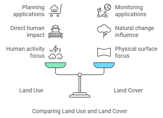
The difference between land use and land cover lies in their definitions: land use refers to how humans utilize land for activities like farming or urban development, while land cover describes the physical material on the surface, such as forests, water, or built-up areas.
What is Land Use?
Land use refers to how humans utilize different parts of the land for various activities. This could include residential areas, commercial zones, farming, and conservation efforts. Essentially, land use focuses on the purpose assigned to a particular area.
Think about an urban environment. You’ll see areas dedicated to homes, shopping centers, parks, and factories. Each of these has a specific land use purpose, driven by human needs and economic activities. Land use planning is critical because it affects how cities grow, how agriculture is practiced, and even how conservation zones are maintained to protect natural habitats.
Examples of Land Use Include:
- Residential Areas: Areas designated for homes and housing developments.
- Agricultural Practices: Land used for growing crops and raising livestock.
- Conservation Zones: Areas set aside to protect wildlife and natural resources.
- Industrial Sites: Spaces for factories and other industrial activities.
What is Land Cover?
Land cover, on the other hand, describes the physical features on the earth’s surface. This could be forests, lakes, grasslands, or even man-made structures like roads and buildings. While land use focuses on purpose, land cover focuses on what physically exists in an area.
The concept of land cover helps scientists, planners, and conservationists understand the natural state of a region. Land cover mapping involves determining the distribution of forests, wetlands, water bodies, and more. This is important for assessing natural landscapes, monitoring environmental changes, and predicting potential hazards.
Examples of Land Cover Include:
- Vegetation Analysis: Trees, shrubs, and other plant life that exist in an area.
- Water Bodies: Lakes, rivers, and ponds covering the landscape.
- Built-up Areas: Urban structures, buildings, and paved surfaces.
- Soil and Bare Ground: Areas not covered by vegetation or other natural features.
Key Difference Between Land Use and Land Cover
The main difference between land use and land cover is that land use is about how people decide to use the land, while land cover is about what is physically present on that land.
- Land Use = Human Purpose: It deals with the activities, like farming, construction, and recreation, that people carry out.
- Land Cover = Physical Features: It refers to what’s actually covering the ground, such as trees, water, or pavement.
Understanding this difference helps planners, scientists, and policymakers manage natural resources, reduce environmental impacts, and foster sustainable development.
For instance, changes in land cover due to deforestation directly impact land use by affecting agricultural possibilities and conservation efforts.

Side-by-Side Comparison Table: Land Use Vs. Land Cover
| Criteria | Land Use | Land Cover |
|---|---|---|
| Definition | Human activities on land | Physical surface of land |
| Human Interaction | Direct impact through activities | Changes from natural or human actions |
| Applications | Urban and environmental planning | Ecosystem monitoring |
| Data Collection | Surveys, government data | Remote sensing, spatial data |
| Environmental Impact | Influences on biodiversity | Affects local climate and water cycle |
Why is Understanding Land Use and Land Cover Important?
Understanding land use and land cover is vital for effective land management and environmental protection. These concepts help us understand how our activities impact the world and how we can minimize negative consequences.
Applications Include:
- Urban Development: Deciding where to place roads, parks, and residential areas.
- Agricultural Practices: Determining the best areas for crops based on soil quality and water availability.
- Forest Management: Balancing timber production with conservation of ecosystems.
- Wetland Identification: Recognizing and preserving crucial wetland areas that support biodiversity.
The Role of Remote Sensing in Land Use and Land Cover
Remote sensing analysis plays a key role in identifying both land use and land cover changes. By using satellites and aerial imagery, experts can gather spatial data about an area to understand its features and track changes over time.
Land Cover Change: Remote sensing is often used to monitor changes in land cover, such as deforestation rates or the spread of urban areas. With technologies like satellite imagery, we can observe how forests transform into urban landscapes or agricultural zones.
Land Use Classification: It also aids in understanding how different land uses evolve over time, especially in areas of rapid development. This technology helps governments and organizations make informed decisions regarding urban expansion and conservation strategies.
Examples of Land Use and Land Cover Changes
Changes in land use and land cover are a natural part of the evolving human and natural landscape. However, understanding these changes helps us address concerns like habitat fragmentation, environmental degradation, and over-exploitation of resources.
Common Examples Include:
- Urban Expansion: When rural areas are developed into built-up areas for housing or commercial use.
- Deforestation: Forests cleared for agricultural land or human settlement.
- Wetland Loss: Wetlands being drained for zoning regulations and urban development.
- Agricultural Intensification: Converting grasslands into agricultural fields to meet growing food demands.
Human Activities and Their Impact on Land Cover
Human activities have a significant impact on land cover. Urban development, agriculture, and conservation efforts all play roles in shaping the landscape.
- Urban Development often leads to the transformation of forests, grasslands, or agricultural fields into built-up areas.
- Agricultural Expansion may result in the removal of natural vegetation, leading to changes in land cover.
- Conservation Zones, on the other hand, help to protect existing land cover types, such as forests and wetlands, ensuring these ecosystems remain intact.
Understanding these impacts is crucial for creating sustainable land management strategies that balance human needs with environmental health.
The Importance of Land Use Planning
Land use planning is crucial for sustainable growth. It involves careful analysis of existing land uses and projected future needs to make the best use of available land. This kind of planning ensures that urban areas grow in a way that considers environmental, economic, and social factors.
Benefits of Effective Land Use Planning:
- Reduced Habitat Fragmentation: Proper planning can minimize the division of natural habitats, allowing wildlife to thrive.
- Sustainable Agricultural Practices: Ensuring the land remains fertile and productive for future generations.
- Balanced Urban and Rural Development: Promoting the growth of urban areas while conserving natural landscapes.
Conclusion
Understanding the difference between land use and land cover is vital for anyone involved in land management practices or environmental conservation. While land use focuses on human activities and how land is utilized, land cover describes the physical features present on the earth’s surface. By recognizing and understanding these concepts, we can make more informed decisions that promote sustainable development, protect the environment, and improve the quality of human life.
For more information about land use and land cover, check out related articles on remote sensing in land use and land cover and land use planning applications.
FAQs:
What is land use vs. land cover?
Land use refers to how humans use land, while land cover describes the physical material present, such as forests or water bodies.
Why is land use planning important?
Land use planning helps in managing resources effectively, ensuring sustainable growth, and reducing negative environmental impacts.
How does remote sensing help with land use and land cover?
Remote sensing uses satellite imagery to monitor changes in land cover and help classify different types of land use.
What are examples of land use?
Examples of land use include residential areas, agricultural practices, conservation zones, and industrial sites.
How do human activities affect land cover?
Human activities like urban development, deforestation, and agriculture can significantly alter natural land cover, impacting ecosystems and biodiversity.
