Google Earth Pro is a powerful tool that is capable of exploring the world from many new perspectives. It’s capabilities range from viewing high-resolution satellite imagery to getting a detailed view of natural landscapes with terrain data to measuring distances and creating 3D models. In this article I will try to answer all yours Google Earth Pro Questions.
What Is The Purpose Of Google Earth Pro?
With Google Earth Pro, you can access and explore the world from many new perspectives.
You can view high-resolution satellite imagery, get a detailed view of natural landscapes with terrain data, measure distances, create 3D models of buildings and other structures in your area, and more.
#1. How Much Is Google Earth Pro License?
Earlier Google Earth Pro License ranged from $399/year. It is now free to download and use. It comes with features like unlimited downloads of KML and KMZ data files for 3D viewing, high-resolution imagery, time-based animations and more.
#2. What Projection Does Google Earth Use?
Google Earth Pro uses a projection method called Mercator to show the shape of the Earth on their maps.
Google Earth uses the WGS84 datum for latitude and longitude.
WGS84 is a geodetic datum that was finalized in 1984. It is the most commonly used for GPS, WGS84 and it is the datum most commonly used by Google Earth.
#3. How Often Are Google Earth Maps Updated?
When a new satellite image is taken, the map has to be updated. Google Earth has an update cycle of every six months.
The maps on Google Earth are updated every six months, with new satellite images that are taken. Google Earth Maps are very detailed and updated all the time.
#4. How To Use Google Earth Without Downloading?
Yes, if you’re using Google Earth on the web, you don’t need to download anything. Just head to https://earth.google.com/web/ and start exploring the globe!
You can also download Google Earth Application for your Android and iOS Phones.
#5. Why Is Google Earth So Blurry Now?
Google Earth has been criticized for the low quality satellite images that it displays. It is said that the satellite images are pixelated and blurry because of how it captures and processes images.
It may be due to some reasons. If your internet connection is slow then you might face difficulty while browsing or downloading images in Google Earth Application.
The reason for the low quality satellite images is due to the compression algorithm used in Google Earth which reduces file size by shrinking the pixels in order to reduce bandwidth costs.
It was speculated that Google Earth was using a low-resolution, older version of its maps. But this theory was disproved when Google Earth presented what is known as “Google Earth Pro” which had crisper images than its predecessor.
#6. What Is The Highest Resolution In Google Earth?
The highest image resolution in Google Earth ranges from 15 meters to 15 centimeters.
Google Earth uses Digital Elevation Model Data from NASA’s Shuttle Radar Topography Mission.
#7. Can You Get Old Google Earth Pictures?
Old pictures of places are a great way to remember the past. This is especially true for places that have undergone dramatic changes over time.
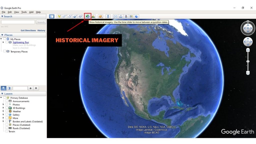
From Google Earth version 5.0, they introduce Historical Images, which allows users to view old images.
Google has been preserving old satellite images of Earth in its archives and you can find them with their “Show Historical Imagery” tool.

The tool will take you back in history, so you can see how your neighborhood, city, or country has changed over time. Google Earth Pro constantly adds new images, so the archive keeps growing and getting more detailed as more pictures are taken each year.
#8. How Do Google Earth Get Their Images?
There are many sources for this information, but most of the data is generated from aerial photography of the earth’s surface. Images are taken using cameras mounted on satellites and aircrafts.
Aerial photography is an ancient technique that has been used for centuries to document landscapes and map out territories. The first aerial photographs were taken in the late 1858s by Gaspar Felix Tournachon, also known as “Nadar”. But today’s aerial photos are taken using aircraft flying at altitudes of over 10 kilometers (6 miles).
#9. What Satellite Does Google Earth Use?
The satellite that Google Earth uses is called the Landsat 8. It is an earth imaging satellite launched in 2013 and still in operation. It captures images with high quality and more frequency than Landsat 7.
Landsat is managed by the U.S. Geological Survey, but it was originally a joint project with NASA and the Department of Defense that was initiated in 1966 to provide long-term data on changes of Earth’s natural resources and environment.
Conclusion
Google Earth Pro is an amazing application for those who love to explore the world. It allows you to go anywhere and see everything from the sky. It has more features than the free version of Google Earth, and it offers a lot of benefits for professionals who need to analyze data in 3D.
With this tool, people can explore the world from their desktop with 360° views that can be explored by clicking on particular points on the map or tilting the screen in any direction.
