
FalconView
Flight Simulation Software For Flight Planning & Combat Simulations.
Pros
Flight Simulator Included
Support for KML/KMZ & MrSID
Satellite Images, Elevation maps & Aeronautical Charts
Cons
Complicated & non-intuitive interface
Limited GIS and Cartography Functions
FalconView is a powerful system for modelling, simulating and visualizing remote sensing data. Its development began in 1993 by Georgia Tech Research Institute. It provides Moving map functionality based on a connected GPS device.
The U.S. Department of Defense has been using the FalconView software program for many years to analyze and display geographical data crucial for its military planners.
FalconView by Georgia Tech Research Institute
FalconView is an interactive mapping system that was originally developed by the Georgia Tech Research Institute and has grown to be successful for Windows, macOS, as well as Linux & Mobile.
In 2014, FalconView 3D & FalconView Mobile editions were announced. 3D Version provide improved support for the surface mission and the Mobile version provide core capabilities to android and iOS mobiles.
By using this software you can display various types of maps and geographically referenced overlays like dem, contours etc.
You can also use maps like satellite images, elevation maps & aeronautical charts.
FalconView supports different overlay types, which can be displayed over any map. They’re handy for military purposes and mainly used by aviators.
FalconView Software
The program’s ease of use, open architecture and interoperability have all helped to make it popular. It has over 45,000 users before the free open-sourced version was released.
FalconView is a part of PFPS – Portable Flight Planning Software Suite.
It includes FalconView,
CFPS – Combat Flight Planning Software,
CWDS – Combat Weapon Delivery Software,
CAPS – Combat AirDrop Planning Software and other software packages.
FalconView Imagery Support
FalconView software support many vectors and raster image format, details are:
- GeoTIFF
- Digital Terrain Elevation Data
- MrSID
- GeoPDF
- WMS
- Shapefiles
- KML/KMZ File
- CADRG (Compressed Arc Digital Raster Graphics)
- Vector Product Format
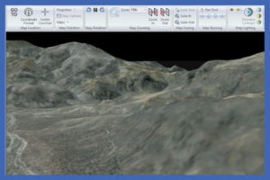
You can use Skyview mode which lets you fly through terrain overlay with the help of a keyboard or joystick.
Contours can be generated from elevation data and can also overlay using FalconView.
Summary
If you work with aviation or nautical charts, you might want to take a look at FalconView. We found it to be most useful for flight routing and doesn’t support other, less specialized needs.
You might find this is the perfect piece of software for simulation!
FAQ:
Where Can I Download FalconView Open Source?
You can download FalconView Open Source software from its official website.
What are the FalconView system requirements?
The FalconView system requirements are not that high. It can be used on many different platforms and it is compatible with Mac, Windows or Linux.
FalconView is reported to run on 64-bit versions.